![](/images/other/stat-length.png)
![Tocht Te voet Les Clées - fixme - fixme - Photo](https://media.geolcdn.com/t/1900/400/69516fc4-f099-4dd3-b5b2-2f14f3d78d3c.jpeg&format=pjpeg&maxdim=2)
fixme - fixme
SityTrail - itinéraires balisés pédestres
Tous les sentiers balisés d’Europe GUIDE+
![Lengte](/images/other/stat-length.png)
Lengte
4,1 km
![Max. hoogte](https://static1.geolcdn.com/siteimages/upload/files/1508320355ic_sort_altitude_max_24dp.png)
Max. hoogte
714 m
![Positief hoogteverschil](https://static1.geolcdn.com/siteimages/upload/files/1508320355ic_sort_den_pos_24dp.png)
Positief hoogteverschil
164 m
![Km-Effort](/images/other/stat-length.png)
Km-Effort
5,9 km
![Min. hoogte](https://static1.geolcdn.com/siteimages/upload/files/1508320355ic_sort_altitude_min_24dp.png)
Min. hoogte
578 m
![Negatief hoogteverschil](https://static1.geolcdn.com/siteimages/upload/files/1508320355ic_sort_den_neg_24dp.png)
Negatief hoogteverschil
41 m
![Boucle](https://static1.geolcdn.com/siteimages/upload/files/16400158638029165_repeat_loop_refresh_sync_direction_icon.png)
Boucle
Neen
Markering
Datum van aanmaak :
2022-02-14 08:55:21.518
Laatste wijziging :
2022-02-14 08:55:21.518
![Te voet](https://static1.geolcdn.com/sitytour/trail-icons/100.png)
1h20
Moeilijkheid : Gemakkelijk
![Scan deze QR-code om de tocht te openen in de SityTrail-applicatie](https://capi.geolives.com/qq0zvz2zws4bq2lad0pu/sitytour/trails/3106755/qr.png?size=200)
Gratisgps-wandelapplicatie
Over ons
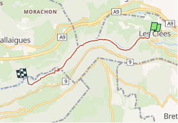
Tocht Te voet van 4,1 km beschikbaar op Waadland, District du Jura-Nord vaudois, Les Clées. Deze tocht wordt voorgesteld door SityTrail - itinéraires balisés pédestres.
Beschrijving
fixme - fixme
Symbol: losange jaune
Plaatsbepaling
Land:
Switzerland
Regio :
Waadland
Departement/Provincie :
District du Jura-Nord vaudois
Gemeente :
Les Clées
Locatie:
Unknown
Vertrek:(Dec)
Vertrek:(UTM)
305983 ; 5178399 (32T) N.
Opmerkingen
Wandeltochten in de omgeving
![Tocht Te voet Les Clées - Tourisme pédestre - Photo](https://media.geolcdn.com/t/375/260/69516fc4-f099-4dd3-b5b2-2f14f3d78d3c.jpeg&format=jpg&maxdim=2)
![Te voet Te voet](https://static1.geolcdn.com/sitytour/trail-icons/100.png)
Tourisme pédestre
Te voet
Gemakkelijk
Les Clées,
Waadland,
District du Jura-Nord vaudois,
Switzerland
![](/images/other/stat-length.png)
3,5 km | 4,5 km-effort
1h 0min
![](https://static1.geolcdn.com/siteimages/upload/files/16400158638029165_repeat_loop_refresh_sync_direction_icon.png)
Neen
![Tocht Te voet Ballaigues - Ballaigues-Vallorbe - Photo](https://media.geolcdn.com/t/375/260/94e39ae2-cd96-4289-ab6b-b58b7f70c35d.jpeg&format=jpg&maxdim=2)
![Te voet Te voet](https://static1.geolcdn.com/sitytour/trail-icons/100.png)
Ballaigues-Vallorbe
Te voet
Gemakkelijk
Ballaigues,
Waadland,
District du Jura-Nord vaudois,
Switzerland
![](/images/other/stat-length.png)
5,1 km | 6,3 km-effort
1h 25min
![](https://static1.geolcdn.com/siteimages/upload/files/16400158638029165_repeat_loop_refresh_sync_direction_icon.png)
Neen
![Tocht Te voet Juriens - TP Mollendruz - Romainmôtie - Photo](https://media.geolcdn.com/t/375/260/dev_7316eb13-f07d-4453-9d47-20985e85773c.jpeg&format=jpg&maxdim=2)
![Te voet Te voet](https://static1.geolcdn.com/sitytour/trail-icons/100.png)
TP Mollendruz - Romainmôtie
Te voet
Gemakkelijk
Juriens,
Waadland,
District du Jura-Nord vaudois,
Switzerland
![](/images/other/stat-length.png)
7,8 km | 11,6 km-effort
2h 38min
![](https://static1.geolcdn.com/siteimages/upload/files/16400158638029165_repeat_loop_refresh_sync_direction_icon.png)
Neen
![Tocht Stappen Jougne - Aiguilles de Baulmes - Suisse - Photo](https://media.geolcdn.com/t/375/260/ext.jpg?maxdim=2&url=https%3A%2F%2Fstatic1.geolcdn.com%2Fsiteimages%2Fupload%2Ffiles%2F1553511878bg_sport_marche.png)
![Stappen Stappen](https://static1.geolcdn.com/sitytour/trail-icons/101.png)
Aiguilles de Baulmes - Suisse
Stappen
Moeilijk
(1)
Jougne,
Bourgondië-Franche-Comté,
Doubs,
France
![](/images/other/stat-length.png)
16,4 km | 26 km-effort
5h 33min
![](https://static1.geolcdn.com/siteimages/upload/files/16400158638029165_repeat_loop_refresh_sync_direction_icon.png)
Ja
![Tocht Te voet Montcherand - Chemin nature pour tous - Photo](https://media.geolcdn.com/t/375/260/28c3b604-46cd-4448-8b43-f68d3bef78bf.jpeg&format=jpg&maxdim=2)
![Te voet Te voet](https://static1.geolcdn.com/sitytour/trail-icons/100.png)
Chemin nature pour tous
Te voet
Gemakkelijk
Montcherand,
Waadland,
District du Jura-Nord vaudois,
Switzerland
![](/images/other/stat-length.png)
3,8 km | 5,3 km-effort
1h 11min
![](https://static1.geolcdn.com/siteimages/upload/files/16400158638029165_repeat_loop_refresh_sync_direction_icon.png)
Neen
![Tocht Stappen Jougne - La poyette - Photo](https://media.geolcdn.com/t/375/260/7455827d-3f9e-4079-9524-3e53ae00a5a5.jpg&format=jpg&maxdim=2)
![Stappen Stappen](https://static1.geolcdn.com/sitytour/trail-icons/101.png)
La poyette
Stappen
Medium
Jougne,
Bourgondië-Franche-Comté,
Doubs,
France
![](/images/other/stat-length.png)
11,8 km | 17,9 km-effort
4h 7min
![](https://static1.geolcdn.com/siteimages/upload/files/16400158638029165_repeat_loop_refresh_sync_direction_icon.png)
Ja
![Tocht Stappen Jougne - Jougne-Le-Suchet - Photo](https://media.geolcdn.com/t/375/260/78012b04-1d56-4360-8011-a370510b5e39.jpg&format=jpg&maxdim=2)
![Stappen Stappen](https://static1.geolcdn.com/sitytour/trail-icons/101.png)
Jougne-Le-Suchet
Stappen
Moeilijk
Jougne,
Bourgondië-Franche-Comté,
Doubs,
France
![](/images/other/stat-length.png)
15,9 km | 25 km-effort
4h 40min
![](https://static1.geolcdn.com/siteimages/upload/files/16400158638029165_repeat_loop_refresh_sync_direction_icon.png)
Ja
![Tocht Fiets Lignerolle - Lignerolle - La Chaux de Fonds ( Jura Suisse) - Photo](https://media.geolcdn.com/t/375/260/ext.jpg?maxdim=2&url=https%3A%2F%2Fservices.sitytrail.com%2FGeolivesWS%2FDownloadMedia.ashx%3FTrailID%3D817692%26Media%3Dfix__20170823181233.jpg)
![Fiets Fiets](https://static1.geolcdn.com/sitytour/trail-icons/200.png)
Lignerolle - La Chaux de Fonds ( Jura Suisse)
Fiets
Zeer moeilijk
Lignerolle,
Waadland,
District du Jura-Nord vaudois,
Switzerland
![](/images/other/stat-length.png)
81 km | 103 km-effort
8h 25min
![](https://static1.geolcdn.com/siteimages/upload/files/16400158638029165_repeat_loop_refresh_sync_direction_icon.png)
Neen
![Tocht Andere activiteiten Romainmôtier-Envy - y10_Cascade du Dard - Photo](https://media.geolcdn.com/t/375/260/ext.jpg?maxdim=2&url=https%3A%2F%2Fstatic1.geolcdn.com%2Fsiteimages%2Fupload%2Ffiles%2F1545311037marcheuse_200dpi.jpg)
![Andere activiteiten Andere activiteiten](https://static1.geolcdn.com/sitytour/trail-icons/900.png)
y10_Cascade du Dard
Andere activiteiten
Heel gemakkelijk
Romainmôtier-Envy,
Waadland,
District du Jura-Nord vaudois,
Switzerland
![](/images/other/stat-length.png)
7,4 km | 8,7 km-effort
2h 7min
![](https://static1.geolcdn.com/siteimages/upload/files/16400158638029165_repeat_loop_refresh_sync_direction_icon.png)
Neen